How Wildfire Spreads
The behavior and severity of wildfire result from a combination of three inter-related factors:
Climate and weather,
Topography and physical setting, and
Availability of combustible fuels.

Climate and Weather
Temperature, humidity, precipitation and wind are each important weather variables that influence the intensity and spread of fire.
Increased temperature combined with low humidity can result in higher combustibility of vegetation and other fuels, such as wood structures. Prolonged dry spells intensify the combustibility of vegetation and other fuels, while precipitation increases humidity and can prevent fire ignition or dampen fire spread.
Significantly, wildfires often create their own weather effects by superheating the surrounding atmosphere, resulting in increased drying and combustibility of fuel sources as well as uplifting of embers and more intense winds and cross-currents. Even before the flames of a wildfire reach a particular location, the energy released through convection and thermal radiation from the wildfire’s front heats the surrounding air to 800° C, which preheats and dries flammable materials, causing them to ignite faster and accelerate the spread of fire.
Wind increases the supply of oxygen to a fire and can distort or alter the path or direction of fire. Wind can also accelerate the pre-heating of fuels downwind from the leading edge of fire, accelerating the rate of fire spread. And it can cause an uplift and spread of burning embers at great distances from the fire, resulting in additional sources of fire ignition far from the fire’s leading edge.
Over time climatic changes in seasonal weather patterns can alter the distribution of vegetation and fuels as well as their susceptibility to fire ignition or spread. For example, years of precipitation followed by prolonged dry spells or increased temperatures can result in more widespread fires or longer fire seasons. Since the mid-1980s, climatic warming and earlier snowmelt have been associated with an increasing length and severity of the wildfire season in the western United States. Such climatic changes can also affect the availability of adequate water resources to fight wildfires.
Topography and Physical Setting
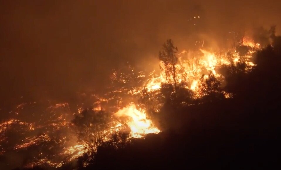
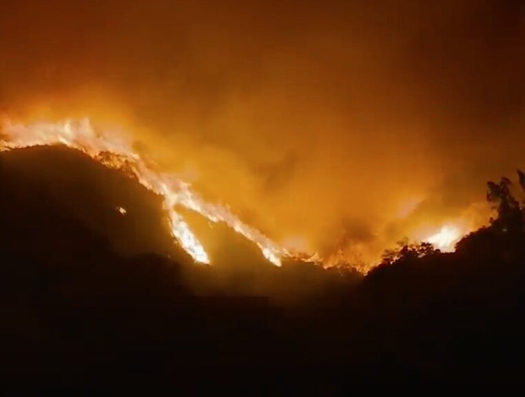
Topography dramatically affects the behavior and spread of wildfire. Because heat rises, the heat energy released through convection and thermal radiation rises up slopes at an increased rate of spread. The angle and orientation of slope are also important, as is the nature and extent of vegetation on a slope. In general, the steeper the slope, the faster the spread. Slopes exposed to longer hours of sunlight tend to have lower humidity, higher temperatures and more combustible fuels.
Canyon walls act as channels directing winds to spread fire in unexpected directions. Steep ravines can act as funnels or chimneys intensifying and accelerating the upward progression of fire to ridgetops and adjoining canyons or ravines.
Four topographical factors influence fire behavior: slope. aspect, terrain and elevation.
Slope. As a first order effect, slope can dramatically influence the expansion and spread of fire. Flames are closer to uphill fuels, heating and igniting them even before reaching them. Rising convective heat expands uphill where it heats and dries new fuels. Convective air may also carry embers upward where wind currents can cause the embers to spread and ignite new fires above and away from the initial fire. Fire suppression efforts are hampered and slowed on slopes. Cooling at night can cause winds to blow downhill, altering the direction and spread of fire.
Aspect. The orientation and exposure of slope to the sun’s heating and drying effects also influences the propensity for fire expansion and spread. Aspect not only determines the duration and intensity of a slope’s exposure to sunlight, but also the type, nature and extent of vegetation present on a slope. A slope directly exposed to long hours of sunlight will generally have higher temperatures and fuels with lower moisture content.
Terrain. Terrain is the complex variation in topography over a landscape, and can have a profound effect on the ability to contain and suppress the expansion and spread of wildfire. It affects local wind patterns as well as the distribution and moisture content of fuels. Terrain restrictions, such as narrow portions of valleys or knolls can act like a funnel to increase wind speed, or cause wind eddies on the leeward side of hills. And steep-side ravines can create “chimney effects” that dramatically increase the rate and intensity of uphill fire spread.
By influencing the rate and direction of fire spread, terrain can also have a profound effect on the availability and adequacy of resources to contain and suppress a fire. For example, depending on the wind, fuel and other variables, a fire at the top of a ridgeline may spread along the ridgeline, downhill or not at all. Alternatively, a ravine with steep slopes climbing upwards in multiple directions can cause a fire at the base of the ravine to spread simultaneously in multiple, widely-separated uphill directions, quickly compounding the resources needed to contain or suppress it.
Elevation. Air temperatures typically follow an elevation gradient, with cooler temperatures at higher elevations. In localized settings, however, atmospheric conditions can cause a band of warmer air to be trapped at mid-elevation between cooler air below and above the band. Within such thermal belts, temperature will be higher and relative humidity lower than in the air below and above the belt, possibly creating unanticipated extreme fire conditions. Over time, the persistence of such conditions can result in localized vegetation that support aggressive fire behavior,
Physical Setting. The specific physical setting of potential ignition sources in relation to topography, potential fuel sources, wind patterns and daytime exposure also affects fire behavior and spread. Ignition sources at the bottom of a slope or the mouth of a canyon will cause and experience different effects than ignition sources in a meadow or on the top of a ridge.
Vegetation, structures and Other Fuel Sources
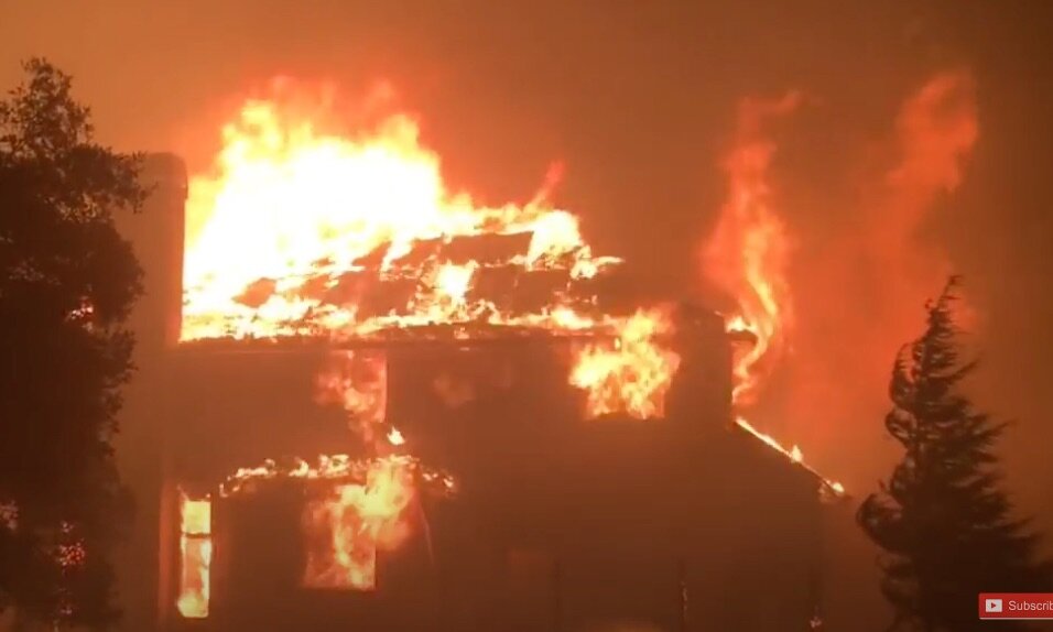
Potential fuel sources for wildfire include living and dead vegetation, such as conifer needles, grasses, brush and small trees, large trees and fallen limbs or logs. Fuel sources also include dwellings, outbuildings, fences, vehicles, storage tanks and gas supply lines. Once ignited, residential structures and other man-made fuel sources release much greater thermal energy over much longer time periods than vegetative fuel sources.
Differences in types of fuel sources can affect the severity and spread of wildfire.
Fine fuels, like needles and grasses, take little energy to ignite, burn rapidly, and can carry and augment the spread of fire.
Ladder fuels are typically shrubs or small trees, which can serve to spread fire from ground hugging grasses or needles up into the tops of larger trees or onto rooftops and into windows and eaves.
Heavy fuels, like large tree, downed logs, large shrubs, dwellings or outbuildings typically require more energy to ignite, but burn longer and produce more radiant heat. They also tend to loft embers into the air.
The distribution, density and geometry of fuel sources also affects the intensity and spread of fire.
canyons and ravines
The manner in which fire rapidly burns through brush-covered canyons and explosively engulfs steep canyon walls and ridge tops was documented in the Los Angeles Fire Departments 1962 documentary on the Bel Air fire, Design for Disaster.
The Seismic Variable
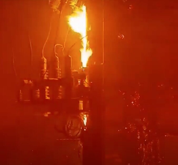
In addition to the three factors driving wildfire severity and spread, a fourth factor looms especially large in Portola Valley: seismic activity and geologic instability. Earthquake and the ground rupture and/or intense shaking it causes can lead not only to structural collapse, but also to downed power lines and ruptured gas lines as well. Each of these occurrences can create separate, discrete sources of fire ignition. Collectively, a seismic event can cause a widespread distribution of multiple fires igniting at multiple points of rupture, collapse or failure. This nightmare scenario is unfortunately all too real along the San Andreas fault zone, and should not be ignored.
To learn more about the expansion and spread of wildfire, watch Design for Disaster, the Los Angeles Fire Department’s 1962 documentary on the Bel Air Fire, a landscape very much like Portola Valley.